

On this page
GIS workshops
Ongoing beginner and advanced in-person GIS workshops are offered by SFU Library's Research Commons.
Custom GIS training sessions are available for classes, research groups, and other groups of brand new or experienced GIS users. Please contact Sarah (Tong) Zhang, , at tza68@sfu.ca to discuss options.
Self-paced online courses
Esri training: Free and subscription online courses
SFU has purchased a site license, which gives current students, faculty, and staff access to the Esri Training self-paced courses free of charge. For beginners to advanced users, these courses cover a variety of GIS topics and provide hands-on experience with downloadable ArcGIS software. To take courses free of charge, follow these steps:
- Explore the courses available via Esri Training. There are many free courses, but SFU students, faculty, and staff also have access to the self-paced online courses. Instructor-led in-person Esri courses are not covered by our license.
- Set up your ArcGIS Online account. If you don't already have an account with ArcGIS Online, please visit this page Getting access to ArcGIS Online and set up your account with your SFU computing ID. Now you should have access to the courses available via Esri Training.
Next time when you need to revisit your courses, follow these steps:
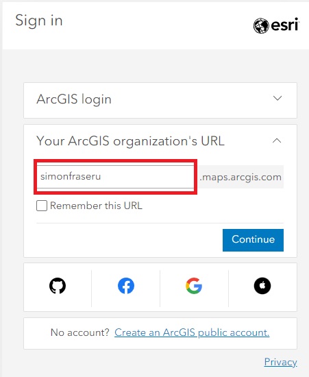
- Log in from the Esri Training page (the top right corner) and click "Your ArcGIS organization's URL" and type in "simonfraseru", click "continue", and sign in with your SFU computing ID.
Alternatively, you can visit https://simonfraseru.maps.arcgis.com/ directly and sign in with your computing ID, and then visit the Esri Training page.
Esri's MOOC (Massive Open Online Course)
Library how-to guides
How to map Canadian Census data
Why and how to map Canadian Census data, using a GIS program or SimplyAnalytics Canada.
How to make images useful for mapping: Georeferencing
Learn how to use QGIS to georeference a historical map, and connect your images with their spatial locations on a reference dataset.
Communicating your research with ArcGIS StoryMaps
Learn how to use ArcGIS StoryMaps, a web-based storytelling tool, to communicate your research.
Introducing ArcGIS Image for ArcGIS Online: working with remote sensing data in the cloud
Learn how to use this a web-based platform to access and work with remote sensing data.
Geocoding: turning addresses into geographic features for mapping
Learn how to convert location descriptions, such as addresses, into geographic coordinates that can be displayed on a map.
Other recommended GIS training resources
Both the University of Toronto Mississauga Library and the University of Waterloo's Geospatial Centre have excellent suites of quick GIS tutorials:
- GIS & Data Tutorials, University of Toronto Mississauga Library
- GIS-related Podcasts and Tutorials, Geospatial Centre, University of Waterloo,
Open Education Resources (OER) for GIS/Geography
Open educational resources (OER) are teaching, learning, and research resources created with the intention of being freely available to users anywhere. For learners, it means you can read them for free; for instructors, it means liberty of access, revision and redistribution.
Open Geography Education
Community-led project compiling OER geography eTexbooks, OER Lab Manuals, and Geospatial Technology OER eTextbooks. Useful to both instructors and students.
Open Educational Resources by Penn State University
A wide variety of GIS-related open courses, ranging from introductory level to advanced level. Licensed by Creative Commons license (cc By-NC-SA 4.0), A few sample courses:
- Open Web Mapping
- Spatial Data Analytics for Transportation
- GIS Programming and Software Development
- Mapping our Changing World
OER GIS by GLOW
A list of GIS OER put together by GLOW (GIS Librarians for Open Workflows).
GIS books at SFU Library
A sample of GIS books available at the Library: