On this page
- What is the ICI Society?
- What ICI Society data do SFU users have access to?
- ICI Society Cadastre
- What is ICI Society Cadastre?
- What data format is ICI Society Cadastre data?
- What attributes are included in the Cadastre data?
- ParcelMap BC
- What is ParcelMap BC?
- ICI Society also provides access to ParcelMap data, then what are the differences between that and ParcelMap BC’s open data?
- Comparing the two:
- How do ICI Society’s cadastral data differ from ICI Society’s ParcelMap data?
- How to access ICI Society data?
- References
SFU Library, as a member of BC’s Integrated Cadastral Information Society (ICI Society), has access to its unique holdings of datasets.This guide will focus on helping you understand the cadastral map data and ParcelMap data it provides. The guide will be useful for any SFU researchers and students who are interested in land-based inquiries and research.
What is the ICI Society?
The ICI Society is a one-of-a-kind data-sharing model in British Columbia. The Society has integrated and shared geospatial data, such as cadastral parcels, civic addresses, utility infrastructure, and municipal zoning, to inform decision-making and support Society Members, their stakeholders, and people in BC.
What ICI Society data do SFU users have access to?
ICI Society provides the following datasets:
- ICI Society Cadastre (subject of this guide)
- ParcelMap BC (subject of this guide)
- AddressBC Data: Address data maintained and provided by Local Government and First Nations is aggregated by the Society to populate AddressBC; a central and authoritative civic address registry for BC.
- BC Assessment Fabric Data: Assessment data maintained and contributed by BC Assessment is a geospatial representation of the assessment roll that utilizes ParcelMap BC spatial alignment.
- Infrastructure Mains
- Zoning
- Fire Hydrants
- Trans Moutain Corporation Pipe Centerline
- Agriculture Land Reserves
- Infrastructure: Infrastructure data maintained and contributed by major Utility organizations operating in BC, including:
- BC Hydro Distribution & Transmission
- FortisBC Electric transmission and electrical distribution assets
- FortisBC Gas transmission and gas distribution assets
- TELUS Communications Facilities, Structures, and Wireless Sites
- Shaw Underground cable infrastructure and assets
- and more.
See a full list of available datasets or the list for available dataset on Abacus (under the Files tab, ICISociety_File_Listing_2024-06.txt. Note that you will need to log in with your SFU credential).
ICI Society Cadastre
What is ICI Society Cadastre?
The ICI Cadastre dataset is a Society aggregated fabric of cadastral data maintained and provided by local government, as well as GeoBC’s Integrated Cadastral Fabric and ParcelMap BC where in use by local government.
What data format is ICI Society Cadastre data?
It offers the data in two formats: shapefiles and geodatabase. You will need a GIS program, such as ArcGIS Pro, or QGIS, to open the files.
What attributes are included in the Cadastre data?
It includes attributes such as PID (Land Title registry identifier), PIN (Crown Land registry identifier), JUROL (BC Assessment folio identifier), parcel’s legal description, ownership classification, etc.
ParcelMap BC
What is ParcelMap BC?
ParcelMap BC, maintained by BC LTSA (Land Title and Survey Authority), provides a web-based visualization tool with the current, complete, and trusted mapped representation of titled and Crown land parcels across British Columbia. A few tiers of access with different viewing privileges are available, including a free guest access tier that does not require an account. Also, ParcelMap BC’s open data is available.
ICI Society also provides access to ParcelMap data, then what are the differences between that and ParcelMap BC’s open data?
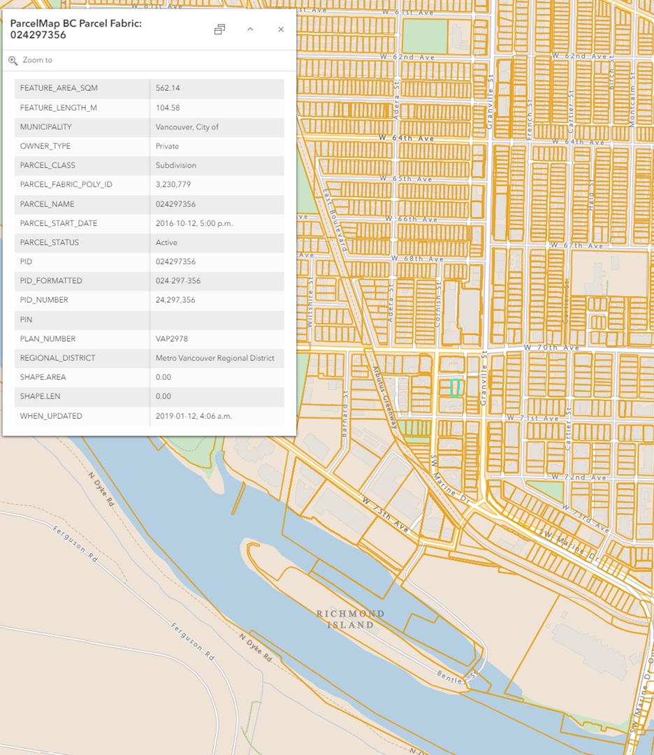
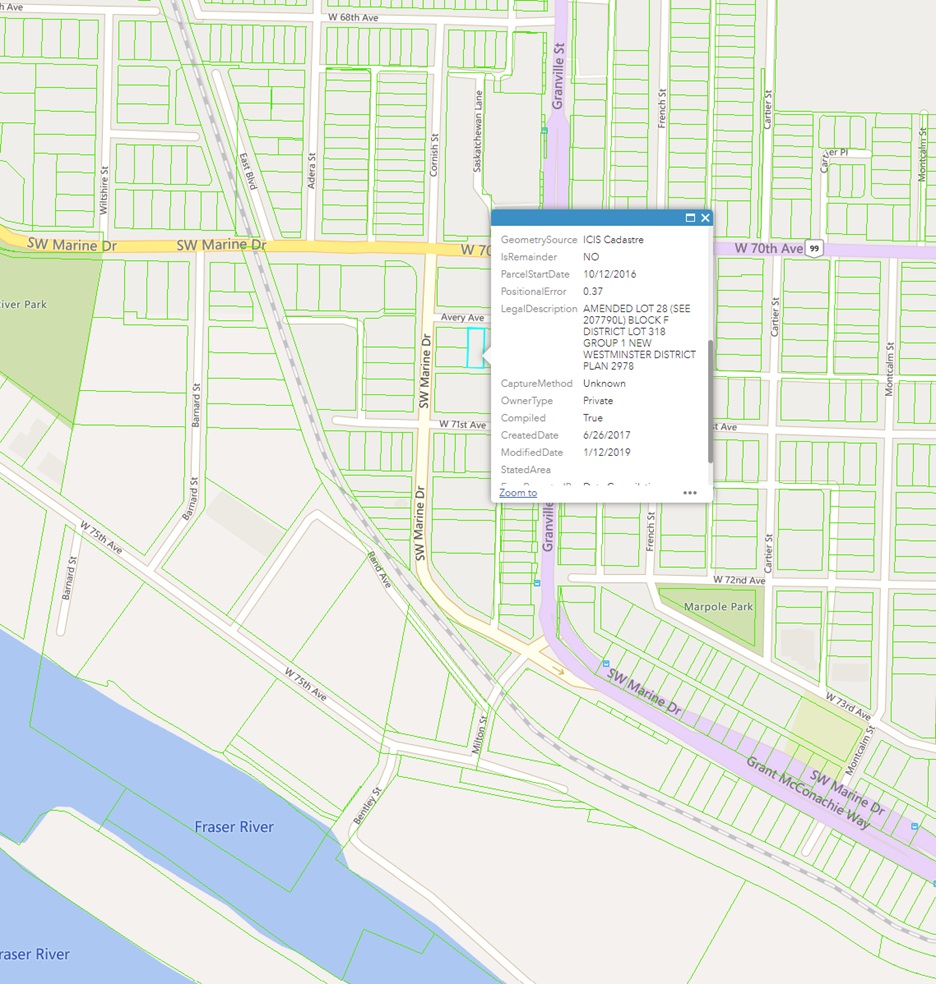
The ParcelMap BC data available through ICI Society has richer legal information than ParcelMap BC’s open data. See the images below.

Image 1 (above): ParcelMap BC’s open data opened in ArcGIS Online

Image 2 (above): ICI Society’s ParcelMap data (with richer legal information)
Comparing the two:
How do ICI Society’s cadastral data differ from ICI Society’s ParcelMap data?
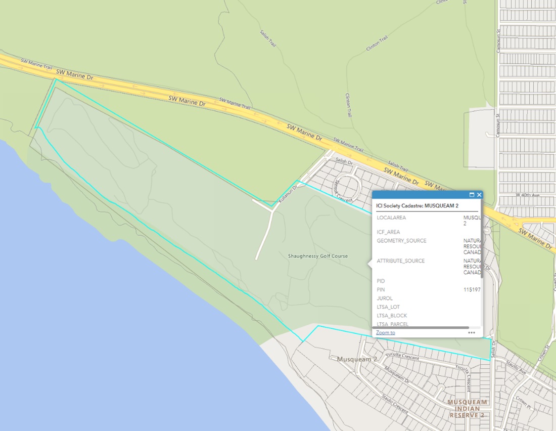
The main difference is that ICIS’s cadastral data includes reserve lands. See an example below.

Image 3 (above): information about a reserve land provided by ICI Society’s cadastral data
How to access ICI Society data?
SFU faculty members, staff, and current students are eligible to access the datasets for research and educational uses. The GIS & Map Librarian (Sarah (Tong) Zhang, tza68@sfu.ca) can download the datasets on behalf of SFU researchers.
References
1. Robbins, P. (2007). Cadastral maps. In Encyclopedia of Environment and Society (Vol. 5, pp. 192-192). SAGE Publications, Inc., https://doi.org/10.4135/9781412953924
